Day 1 (Sections 9 and most of 8)
As I mentioned in my previous post, First Dirt, with the acquisition of a
2021 KTM 890 Adventure motorcycle, I have expanded my horizons from paved roads to the unpaved. The Bureau of Transportation Statistics, a statistics agency in the Department of Transportation, estimates that, as of 2019, there are approximately, 2.9 million miles of paved roads in the USA (an admirable goal for any biker!). Yet, they also estimate another 1.2 million miles of unpaved roads! These cannot be ignored!
Riding off the beaten path onto a beaten path is a completely different experience. First, it requires completely different riding skills. You have to trust the bike. Let the physics work as you slip and slide on the less than perfect traction. But! The experience is also completely different. Each section of road with it's texture and feel heightens your awareness of the ever changing environment.
Backcountry Discovery Routes (BDR) is "a non-profit organization that creates off-highway routes for dual-sport and adventure motorcycle travel." This group has created ten routes, two of which are east of the Mississippi. The Midatlantic Backcountry Discovery Route (MABDR) is:
a scenic ride for dual-sport and adventure motorcycles that uses dirt, gravel and paved roads to wind through remote parts of Virginia, West Virginia, Maryland, and Pennsylvania. Starting in Damascus Virginia, and ending in Lawrenceville, Tioga County, PA, this 1,080-mile route, primarily uses forest roads and rural country lanes, to lead riders through the Appalachian mountains, majestic forests, bucolic farming landscapes, Amish country, and locations that played pivotal roles in early American history.
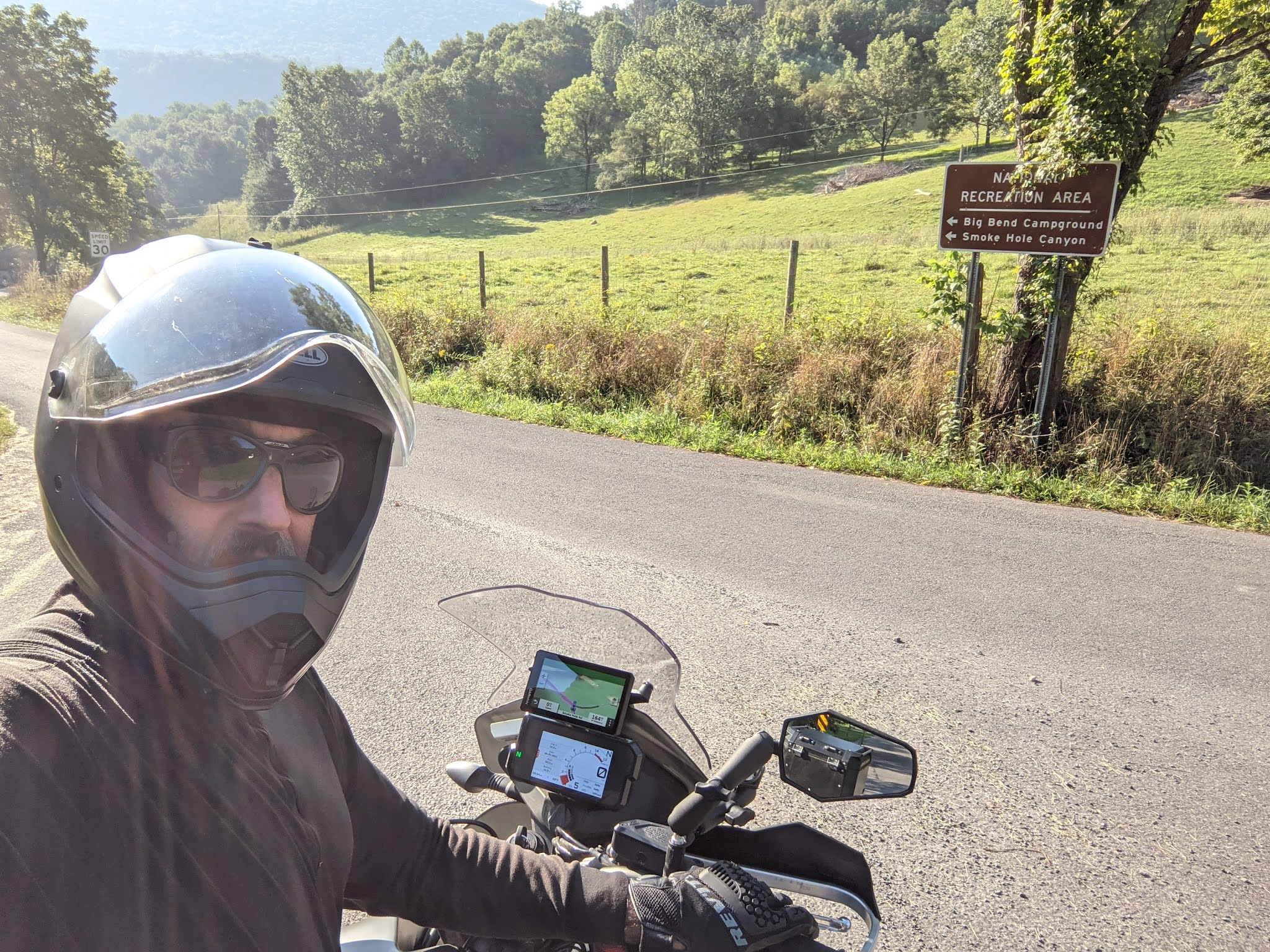
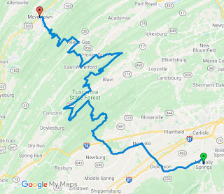
The route is divided from South to North into 9 sections, each of which has its own flavor. I started out riding North to South from my home near Binghamton, NY on Sunday, August 22, 2021 at approximately 8:30AM. It started out as a beautifully sunny day (foreshadowing). I made quick work of the never-to-be-finished I-86/17 West to Corning, NY and from there, down I-99 to Lawrenceville, PA, the official starting (ending?) point of the MABDR.
If you are riding North to South, this
is the "official" start sign, welcoming you to Pennsylvania at the Lawrenceville exit.
Please note that you must obey all posted signs, especially ones that state, "pursue your happiness"! I know I did.
Section 9, from Lawrenceville, PA to Cedar Run, PA,
is the perfect introduction to the MABDR and off road, "adventure" riding. It starts out paved and then slowly progresses to packed dirt
and some gravel as it winds through beautiful farmland and rolling hills.
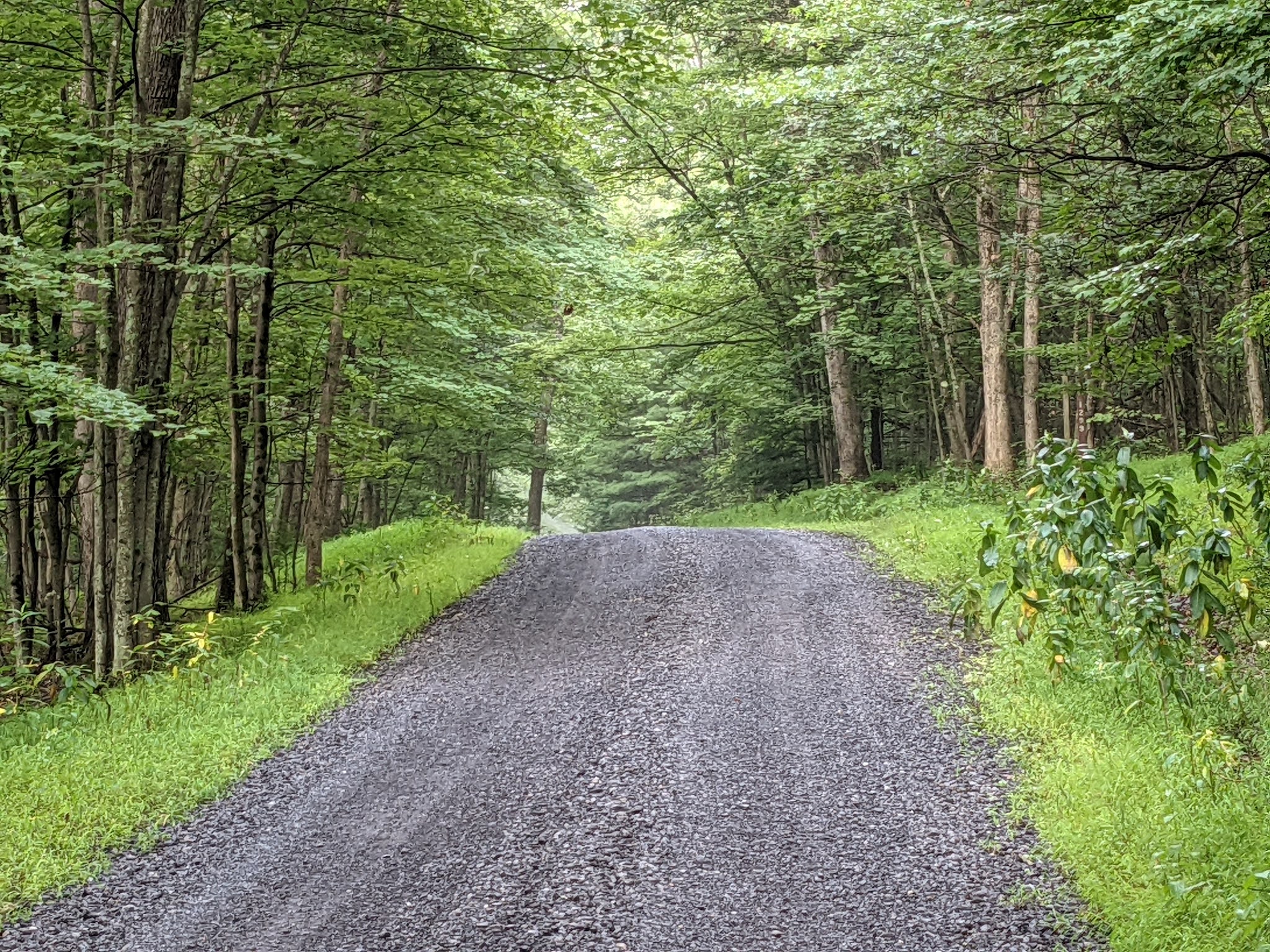
Ironically, there was more than a little traffic on 9, today. I have found, however, that most vehicles will slow and pull over so that motorcycles may continue. 9 then passes you over to Tioga State Forest
and your first, canopies forest road. Instinctively, you take in a deep breath of the somewhat humid forest air.
Now, you are entranced. You leisurely wander through the wood until you are discreetly delivered to US 6.
US 6 is also known as the Grand Army of the Republic Highway. A tribute to the American Civil War Veterans Association, ironic knowing that the MABDR will eventually lead us through many Civil War settings. US 6 is well known to local motorcyclists as a key access to the beautiful riding of central PA and "the PA grand canyon" (more to follow on this).
Turn right on US 6 and you will head to Bishop California. Left, will take you to Provincetown, MA on the tip of Cape Cod (also a wonderful ride). We turn left but only for a little bit before we turn south and join Painter-Leevonia Road
before continuing. The last half of 9, as you wind your way through forested twisties down to Cedar Run, is more training for what is to come on 8. Enjoy every moment.
You break out of the woods with exultation and arrive in the picture perfect town of
Cedar Run.
Cedar Run is best known as a way point for cyclists on the
Pine Creek Rail Trail. Now it also serves as the end point of MABDR 9 and the start of MABDR 8. Visit the General Store.
Yes, they have ice cream. BUT they also have an "everything" topping grilled cheese sandwich that is out of this world. Have a drink, rest, relax. 8 is coming.
8 is the section that will turn you from an adventure/off-road newbie into an adventure/off-road intermediate. Your skills will improve.
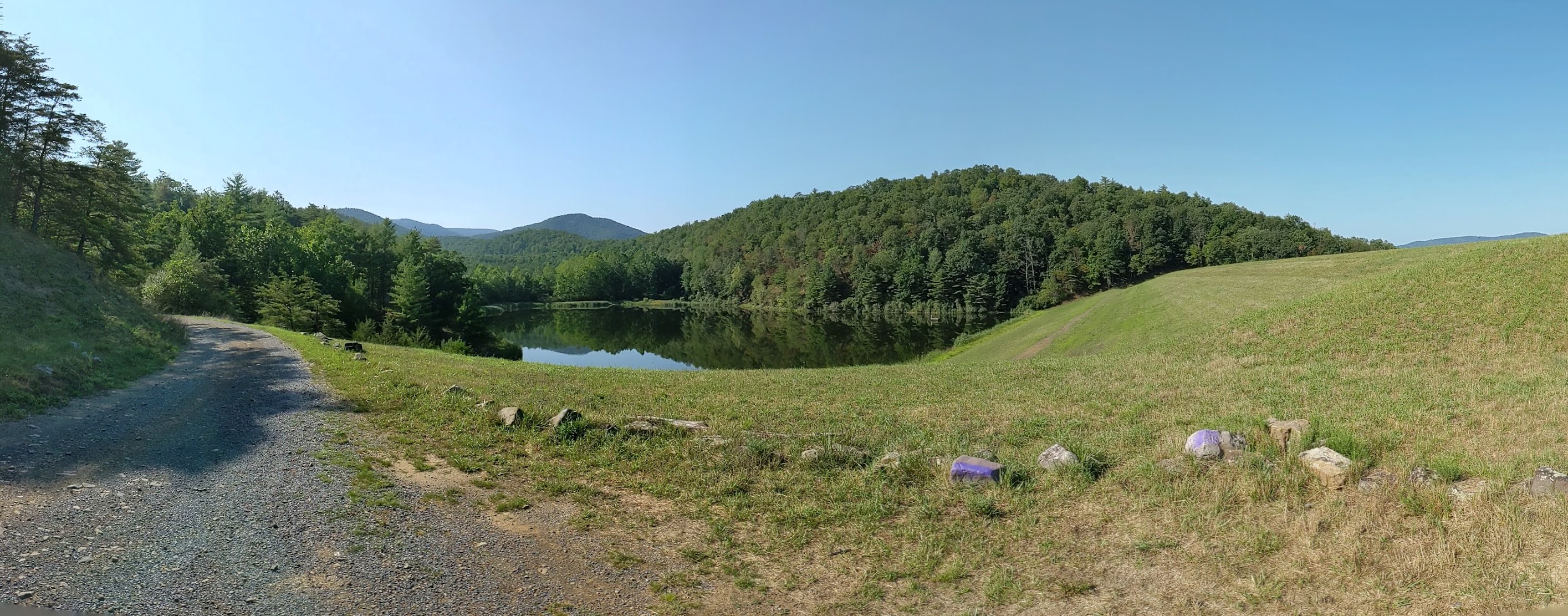
The first part of 8 begins at the end of the main street in Cedar Run where it immediately turns to dirt. From there you climb through some mild wooded roads down to
Little Pine State Park which brings you back to Pine Creek.
Easy riding through the park takes you to Waterville and a mandatory stop for gas and food at McConnell's Country Store.
The second part of 8 runs from Waterville down to the crossing with US 80. It is reasonable to consider stopping for the night on US 220 in the towns of Jersey Shore or Lock Haven. (If you are an aviation enthusiast, the
Piper Aviation Museum in Lock Haven is a must see.) From US 220 to I-80, section 8 is a challenging set of dirt roads with some crazy, rock strewn, hairpins. These challenging roads are dotted with scenic vistas until you empty out onto PA 45 and the end of 8.
The first part of 7
runs from PA 45 to US 322 near State College, PA This segment includes the
Bald Eagle State Park,
Poe Paddy State Park and the
Poe Valley State Park. There is an expert level option through here that I have never seen😂. Stopping for the night in State College, PA or Milroy, PA is a reasonable thought, too. Plenty of places to stay and places to eat as long as there is no home game.
For me, the now steady rain convinced me to stop and I already had reservations in Milroy.
Day 2 (Most of Section 7 and 6)
Day 2 started out beautiful. ("If God is not a
Penn State fan, why is the sky blue?").
This second half of 7 (south of US 322) begins with a good sign!
This park leads to beautiful farmland under an azure sky.
The Greenwood Lake Dam, listed on the the National Register of Historic Places signifies the entrance to
Greenwood Furnace State Park. "The Pennsylvania Department of Conservation and Natural Resources (DCNR) and its Bureau of Parks as one of 25 Must-See Pennsylvania State Parks".
Turkey Hill Road leads you up into the park and onto one of many ridgelines that cross central PA. You continue into the Rocky Ridge Natural area
and then descend into a valley of Amish and Mennonite communities and farms.
then, of course, up on to the next ridge from whence you can see the previous ridge!
All of this before descending into Mcveytown, PA, end of 7 and the start of 6!
6 continues the process of crossing central PA from ridge to ridge.
And the MABDR 6, Bridge out detour. Just follow the bypass and you'll be back on track.
And if you stop in just the right spot, you will see the heartfelt monument of a man to his dog.
Then slowly down off the ridges, through the woods to the fields of central PA to Mt. Holly Spring, the end of 6 and the Start of 5. I chose to stay in Carlisle, PA 5 miles North of Mt. Holly Springs.
Day 3 (sections 5 and 4)
The beginning of 5 is the epitome of adventure riding. You start out in a lovely little town. You turn off the main drag into a neighborhood of well dressed homes on a well paved road. The next turn takes you to slightly more rural homes spread out. there is, perhaps, some loose gravel scattered on the pavement. Another turn takes you to a gentleman farm.
Beyond that the pavement ends. The forest begins. Mailboxes disappear followed shortly by telephone poles. The wood wraps around you.
The Michaux State Forest is magnificent. An interesting bit of WW II history.
I note that portions of the MABDR are mowed!
From there, the route passes between Wofsville and Myersville, MD. Crow Rock Road was closed for tree pruning that morning so I continued on Wistman Road to Harmony Road and back to MD 17.
Of course, Before I could even call the help desk, who should show up? Craig Palen, steward of the MABDR. What fantastic service!
You turn left at St. John Lutheran Church (1790) and continue into
Washington Monument State Park
Onward, now, into West Virginia and to Harper's Ferry along the Potomac.
Civil War sites dot the route.
4 now takes over from 5. You pass Nelson's Supply Company in Hedgesville, WV.
You arrive, then, at the Chesapeake and Ohio Canal at OldTown, MD.
Where I am obligated to inform you that the MABDR from North to South is a TOLL ROAD! $0.50!
For this kind of bridge!
And the "Chessie" still runs.
4 is almost entirely paved road. Don't let that discourage you. It is a beautiful route that let's you refresh yourself from the woods.
Day 4 (Section 3)
Ah, the legendary section 3. 3 turns boys into men; newbies into intermediates. It tests your skills and advances them.
And, you will hit "first water" (and second, third, ...until you lose count). This was my first time crossing water on a motorcycle. I used a tried and true method. Stop, look, first gear, stand up, second gear, say a prayer blessing all the KTM engineers, close my eyes and gun the throttle. Remarkably successful and useful technique.
3 alternates between small sections of beautifully paved roads and extensive ridgelines of gravel hairpin turns.
And more water.
And then, in the middle of nowhere, a secret government installation.
And, of course, at a tight hairpin, the beer memorial. With flag holder for some ceremony for which UI do not know the date!
Maybe you'd like to try some sandy hairpins? Or a hill climb?
But you descend off the last ridges, onto pavement, a better rider than when you went in.
Day 5(Sections 2 & 1)
2 is a beautiful continuation through the woods and ridges of the Jefferson National Forest. It starts out cloudy and foggy in Covington, VA.
I meet up with legendary biker, Pat McCartin, the proprietor of the
Dancing Bear Inn, the unofficial start/end point of the MABDR.
He gives me a guided tour through 2 and 1 including the famous Tub Run Road. What a wild ride! Puts all the skill learned on 3 to the test.
Pat skillfully dodges thundershowers to the west of the route. We arrive at the Inn.
In the morning, I take leave of the dancing bear and head oput to finish the last bit of 1 we missed the evening before. It is spectacular.
The stone tunnel cut to get timber off the mountain is stunning.
As is the view just before I connect with I-81 to head home.
A spectacularly beautiful trip. I have honed old skills and learned new ones. I have challenged myself and come out (alive and) the better for it. Now, 575 miles of slab to get home where, "my love lies waiting, silently for me".


